Extended Trips
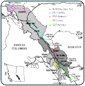
The Great Divide Trail, as described in The Canadian Rockies Trail Guide, is a long-distance hiking route stretching from the southern tip of Banff National Park to Mt. Robson, travelling on or near the Continental Divide. Each section of the route is designated according to a characteristic natural feature. Since the GDT is not yet an official trail, but rather an arbitrary collection of existing, linked trails that form a fairly continuous route for several hundred kilometres, the itinerary described on this site is simply a GDT variant that I have hiked, inspired by an early edition of the CRTG. A glance at the 1:200,000 scale maps published by Parks Canada will reveal other possibilities for GDT routes. Plus, the extensive network of trails in the parks and wilderness areas provides the opportunity to design routes of practically any length, and to include side trips according to one's interests and abilities. The Parks Canada maps are highly recommended for planning backpacking trips, plus they are very useful as road maps. The GDT sections are shown in this map:
Jed Flint has created a printable PDF map of the standard GDT that is based on the route described in Dustin Lynx's "Hiking Canada's Great Divide Trail". It consists of 52, 11x17 pages, and includes the area between Waterton Lakes National Park and Kakwa Lake. The map is about 94 MB, and can be downloaded here.
Since some of the sections pass through more than one park, you may have to arrange camping permits at several offices or information centres, as mentioned in the intro. However, it is possible to obtain a national parks permit at any national parks information centre, even if the trip is not in the same park as the info centre, e.g., a permit for Banff can be obtained at the Jasper office. Permits for most of the provincial parks can be obtained at convenient locations, e.g., Kananaskis, or Mt. Robson Park. Regulations for Mt. Assiniboine Provincial Park depend on the campsite location.